Saturday May 14th
On Saturday, May 14th we visited waters around Ballyhaunis, Co Mayo. Ballyhaunis is situated just a short stone’s throw from three of Ireland’s major catchments: the Moy catchment, the Corrib catchment and the River Suck/Shannon catchments . The area is characterised by fissure33d/karst limestone and has an abundance of springs and limestone waterways .
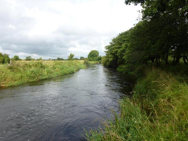
We initially visited the Dalgan River, an important spawning tributary of the River Claire – sometimes referred to as the Clare-Galway River. The Dalgan River flows through the town itself and just upstream of the shops and the busy village streets, it is a beautifully rich limestone stream. It has all of the hallmarks of a very diverse waterway, with very rich flora and holds an abundance of juvenile trout and salmon. It is interesting to note that it is of such importance that Inland Fisheries Ireland have designated the stream as a catch and release area, to ensure that all of the salmonids present are strictly conserved. During our visit it was noted that the stream held an abundance of algae and so-called blanket weed, which may well indicate enrichment further upstream. It is important that every effort is made to locate the source (s) of any enrichment and to deal with these as soon as possible.
We also visited the Island/Mannin areas and had an opportunity to see at first-hand the areas that originally held two important local lakes – Lough Mannin and Island Lake. A survey of the area was carried out by a well known ecologist, Marie Dromey, of Trinity College Dublin, in 1992 . It was very useful and interesting to compare and contrast what Marie had found with the areas present today. We only had a short visit to the area but it did seem to us that little had changed since the 1992 survey and that the wetland created by the drainage of the local Glore River in the 1960s had, as noted by Marie, created a diverse and important wetland area. I’m sure the drainage of the loughs was catastrophic for the local freshwater fauna and the fish populations present but since we have no pre-drainage data of the area, the extent of the losses are tragically unknown. See below an interesting quote from the original survey by TCD.
During our visit we learned that the naming of the rivers and streams locally be can be quite confusing but with the help of some expert local advice we managed to disentangle the naming of the various streams and rivers. It seems that the upper River Gweestion ( close to its source) is known locally as the Gweestín (Little Gweestion in Irish) . As it flows towards the original location of the Island and Mannin Lakes it adopts the name of the Glore River, while downstream of this area it is known as the Gweestion River. The Gweestion catchment is an important tributary of the River Moy and was previously surveyed during the Mayo Caring for Waters course as it has the distinction of holding a Blue Dot designation, indicating top water quality (Blue Dot Programme – Local Authority Water Programme (lawaters.ie) ) .
Finally, we visited the upper reaches of the Gweestín and the outflow from the beautiful marl lake marked on the map as Lough Cheer. The outflow from the lake holds a most impressive selection of natural freshwater flora and would be worthy of a detailed survey, as it may be that the waterway would prove a suitable site for designation as an area of special ecological interest. We could not reach the lake itself, because of the surrounding marshland, but it does appear it may well be a marl lake and for that reason, as in the case of Washpool Lake (near Belcarra), should be carefully surveyed, again with a view to designation.
Quote
Eigse Ltd., Innovation Centre, Trinity College, Dublin
Author: Marie Dromey M.Sc.
December 1992.
Mannin and Island Lakes, Ballyhaunis, County Mayo
Both lake basins are fed by springs and seepage from the surrounding hillsides and are drained by the Mannin/Glore River. From observations of the vegetation type growing in the lakes, it appears that the water is nutrient-poor and low in pollutants reflecting extensive grazing practices. Nutrient levels in the river may be higher. As the water quality of any freshwater system has important implications for the plant and animal communities which it supports, it should be studied. This is particularly true in order to determine if and where nutrients are entering the catchment.
The catchment/site has been arterially drained 30 years ago. Since that time, the ecology of the area has had a chance to recover and the resulting mosaic of habitats may be ecologically richer than the original lakes. The lake bed is still fed by springs ensuring that parts remain wet throughout the year and there is a depth of 5m – 15 cm of water over the original lake-bed area during the winter. The
canalised river running through the site is neither very deep nor wide so it does not severely drain the area. As the drains and outfalls fill in with time, the water levels in the catchment will rise. New drains should not be dug or existing ones deepened. At present, the catchment is a good example of a large wetland with a range of distinct habitats which add diversity to the overall site. Though distinct, these habitats merge into each other according to hydrological requirements. It is this range of wetland communities supplying food and cover which attracts the very large numbers of wintering waterfowl.